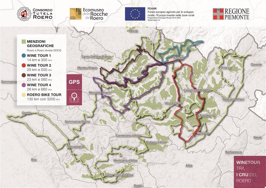
WineTour 2 - Itinerary that goes across the residential core of the Roero’s councils, which face Tanaro River valley: Castellinaldo, Castagnito, Guarene and Vezza d’Alba. It’s a territory that’s shaped with soft and sinuous lines, in which vineyards contend their ground with fruit trees and hazelnut trees.
The Path is NOT marked out: it is recommended to use the GPX track or the audio guide with integrated geolocated map, available on the Izi.Travel smartphone app, freely downloadable on your mobile phone: WineTour 2 – The clayey crus towards the Tanaro River
ITINERARY
Starting from Canale, walkers can go through Roncaglia, Madonna del Cavalli and Baroni Incisa crus to reach the village of Castellinaldo on top of the hill. This council has a cultivated area with vineyards from the Roero territory and a wonderful view. After that, they walk across the extended amphitheater of vineyards of Rocca Cerretto, Serra Zoanni, Leschera, San Quirico and Trono crus, to then get in proximity of Castagnito through the Cortine and Croera crus, from which is worth to get a glimpse at the 360 view offered by San Licerio bric, one of the highest point of the area.
The vineyards that are mostly exposed towards the south/south-west side (Serra Zoanni, San Quirico, Cortine) benefit of an important solar radiation from the central hours of the day until sunset, which means that their soil is rich in clay and silt, but has a less percentage of sand compared to the average soil of this territory.
Vineyards keep on growing in areas which are suitable to give great nutrients to the grapes and if you add a relevant contribution from the sun, it’s logical to expect the Roero territory to be well-structured, allowing the vineyards to mature relatively early because of the warm zone.
The other crus facing Tanaro River valley (Croera, Soarmi, Trono and Leschera) are situated in a pretty cooler zone for both the solar exposition and the proximity to the Tanaro River with its thermoregulatory function, which helps giving structure and a good amount of acidity to the wines.
Continuing the itinerary, walkers go across the elegant town of Guarene with its massive baroque castle and proceed towards Vezza d’Alba walking alongside Montebello and Madernassa crus, surrounded by vineyards and spread out orchards (Madernassa pears, apricots and peaches).
Consequently, they reach the Borbone stream’s plain walking on a road on the valley floor, from which they can admire the steep vineyards of Torion and Patarun crus crawling their way up on the right side, going then up San Michele’s ridge among vineyards that frame the homonymous little parish church and some historical ciabot, closing up the ring path in direction of Canale.
WARNINGS
The Path is NOT marked out: it is recommended to use the map, the GPX track or the audio guide with integrated geolocated map, available on the Izi.Travel smartphone app, freely downloadable on your mobile phone: WineTour 2 – The clayey crus towards the Tanaro River

Some sections of the path can be challenging and technical for use by mountain bike by people with little familiarity with the vehicle.
We recommend to provide you the map of the trail you are going to walk, to equip you with hiking shoes suitable for dirt and, eventually, with trekking poles. In spring/summer is better to have water with you and some energizing food.
Please consult meteorological websites before leaving, and contact the Ecomuseum office or visite our website to verify the trails conditions.
For people allergic to insects bites or pollens is advised to have with you medicinal products to prevent inhalings or bites.
Before leaving, tell someone your destination or the trail you want to walk, in order to simplify first aid assistance in case of necessity.