WineTour through the cru of Roero
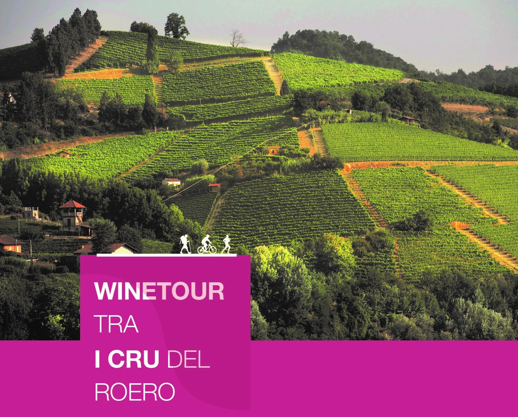
WineTours are 4 new trails through the geographical indications of the Roero and Roero Arneis DOCG wines - also called “cru”- among the historical vineyards and wineries associated to the Roero Producers’ Consortium.
WINETOURS THROUGH THE CRU OF ROERO
The new Roero Trails of 2020
The PROMOTERS:
THE ROERO PRODUCERS' CONSORTIUM
The wine producers of Roero were joined in the Roero Producers’ Consortium (Consorzio Tutela Roero), acknowledged with a decree published in the Official Gazette, on the 4th of March 2014, with the objective to perform the functions of protection, advancement, promotion, consumer information and general care of the interests related to the “Roero” Docg.
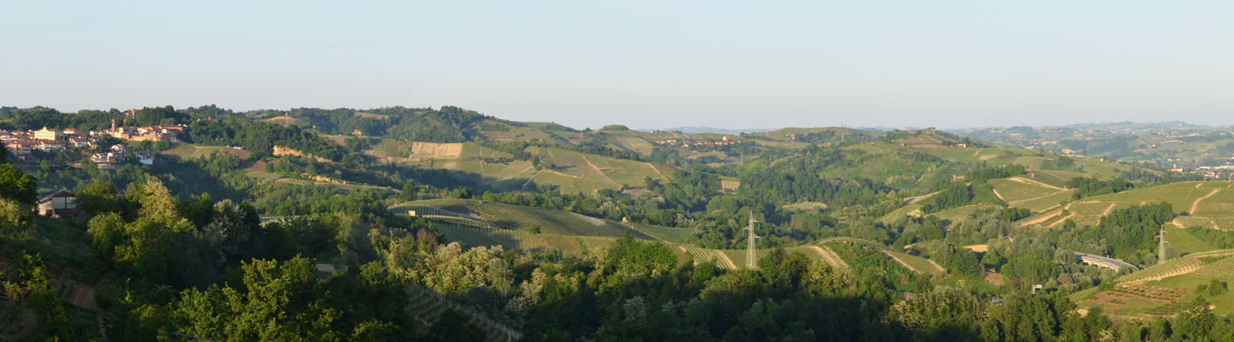
As evidenced by the archives, the art, the landscape and the architecture of the rural houses, the vine and the wine, on the hills of Roero, have always been the culture, passion and pride of the country folk. So much so that the wine producing landscape of Roero, similar to that of Langhe and Monferrato, has been declared a Unesco World Heritage site in 2014.
Arneis and nebbiolo are the two base grapes of the Docg: native grapes, typical of this territory, cultivated for centuries and interpreted with great care by the Roero producers.
The Roero Docg is divided into two wines: Roero, a red wine based on nebbiolo grapes, and Roero Arneis, a white wine based on grapes of the same name.Today there are more than 300 consortium members made up of producers and growers, and more than 1,000 hectares of Roero Denominazione (Designation) vineyards, with a total of about 6 million bottles produced, of which more than 60% are exported. The Roero Producers’ Consortium benefits from erga omnes and, despite the recent constitution, has a membership of more than 50% of wine growers with more then 70% of the Docg production.
THE ECOMUSEO OF ROCCHE OF ROERO
The Ecomuseum of Rocche of Roero was established in 2003 by the Piedmont Region and works to promote and valorize the eight peaks boroughs on the back of the Rocche, a geological erosion phenomenon that cross Roero territory for 40 km.
The Rocche originated about 250,000 years ago, when Tanaro river deviated its course and caused a series of very strong upheavals,incising with deep gorges and picturesque sandy badlands. A delicate ecosystem rich in biodiversity, where humid and dry environments coexist in few hundred meters of altitude.
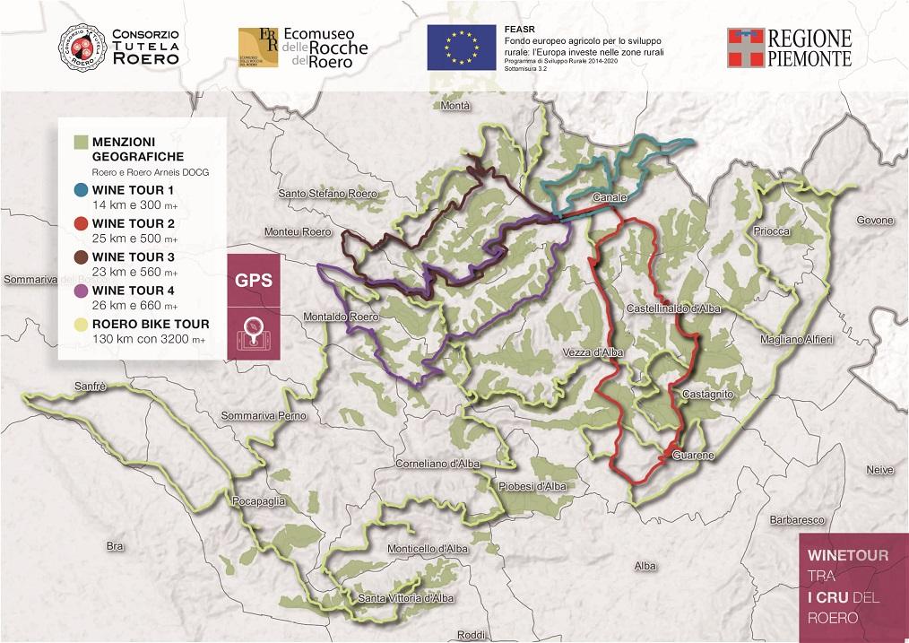
The Ecomuseum has realized a network of Thematic Trails through Rocche ecosystem, dedicated to hiking, trail running and mountain bike’s lovers that can be freely enjoyed in an outdoor museum along woods and hills of Roero. All the Paths are circular and allow to park the car or the bus, go through the Path and return to the starting point. For each Path is available a technical description with difficulty level, the duration and the altitude data. On the website www.ecomuseodellerocche.it it is possible to freely download the GPS track or the audio-videoguide of each path, see the photogallery and to organize an holiday referring to the accommodations linked to every trail.
WineTour 1 – The cru where the Arneis wine was born
It is an itinerary that winds entirely through the council of Canale and crosses a lot of its most famous cru, among which there is the Renesio cru, such as an ancient toponym from which the folksy term “Arneis” was originated, that then meant to indicate the Arneis DOCG’s vineyards and wine.
Going up from the residential area of Canale and from its medieval civic tower towards the Cappuccini’s convent, walkers come across the Renesio cru, which is the cradle of the Roero Arneis and to which are related its own declinations: Renesio Montorone, Renesio Valbellina and Renesio Incisa. Following this path, walkers get to the Granmadre, which has its homonymous rural chapel, to then enter the Loreto cru, next to the small village called “Madonna di Loreto”, which consists of a bunch of houses that are overlooked by the homonymous church built at the end of the fifteenth century. Once here, they go through the Curiano and Mompellini crus, to then come down through the Mompissano , Oesio and San Vittore crus, on which the homonymous parish church rises, the last remain of the original village of Canale. The ring path, at the Mompissano cru’s hight, can be extended to the Canale’s vineyards that are part of the san Defendente, Rabini and Montorino crus and border in direction of San Damiano d’Asti’s castle, to close-up the ring path back in Canale. The soil is the typical one of the Roero territory, which is characterized by the so-called “sabbie d’Asti” (Asti’s sand) in which the percentage of clay and silt are less than the one of the sand, which can reach percentages close to 50-60%. This composition makes the ground way lighter, waterproof and very oxygenated: that’s why the wines produced in this area are very well structured and full of flavors. These fields are positioned as if they would form a sort of amphitheater fully immersed in vineyards, which are exposed facing the south (with clear air excursions blowing towards the south-east and even more towards the south-west), with a great contribution from the solar radiation.
WineTour 2 – The clayey crus towards the Tanaro River
Itinerary that goes across the residential core of the Roero’s councils, which face Tanaro River valley: Castellinaldo, Castagnito, Guarene and Vezza d’Alba. It’s a territory that’s shaped with soft and sinuous lines, in which vineyards contend their ground with fruit trees and hazelnut trees.
Starting from Canale, walkers can go through Roncaglia, Madonna del Cavalli and Baroni Incisa crus to reach the village of Castellinaldo on top of the hill. This council has a cultivated area with vineyards from the Roero territory and a wonderful view. After that, they walk across the extended amphitheater of vineyards of Rocca Cerretto, Serra Zoanni, Leschera, San Quirico and Trono crus, to then get in proximity of Castagnito through the Cortine and Croera crus, from which is worth to get a glimpse at the 360 view offered by San Licerio bric, one of the highest point of the area. The vineyards that are mostly exposed towards the south/south-west side (Serra Zoanni, San Quirico, Cortine) benefit of an important solar radiation from the central hours of the day until sunset, which means that their soil is rich in clay and silt, but has a less percentage of sand compared to the average soil of this territory. Vineyards keep on growing in areas which are suitable to give great nutrients to the grapes and if you add a relevant contribution from the sun, it’s logical to expect the Roero territory to be well-structured, allowing the vineyards to mature relatively early because of the warm zone. The other crus facing Tanaro River valley (Croera, Soarmi, Trono and Leschera) are situated in a pretty cooler zone for both the solar exposition and the proximity to the Tanaro River with its thermoregulatory function, which helps giving structure and a good amount of acidity to the wines. Continuing the itinerary, walkers go across the elegant town of Guarene with its massive baroque castle and proceed towards Vezza d’Alba walking alongside Montebello and Madernassa crus, surrounded by vineyards and spread out orchards (Madernassa pears, apricots and peaches). Consequently, they reach the Borbone stream’s plain walking on a road on the valley floor, from which they can admire the steep vineyards of Torion and Patarun crus crawling their way up on the right side, going then up San Michele’s ridge among vineyards that frame the homonymous little parish church and some historical ciabot, closing up the ring path in direction of Canale.
WineTour 3 – The crus at the edge of the Rocche’s area.
Itinerary that winds its way through the most significant crus located in towns on top of the Rocche, which is a geological erosion phenomenon that characterizes Monta’, Santo Stefano Roero and Monteu Roero, where sandy inaccessible cliffs show themselves, wild, among the cultivated plots.
Starting from Old Town Canale, walkers have to follow directions to Monta’ through Via Torino, in a progressive zigzag that goes all the way up soft hills and skirts the Lamonta’ cru. Then, turning left, they leave the paved road to walk on the unpaved path, crossing a little stretch full of mixed vegetation, to get to a valley road that runs alongside Bric Valdiana and Valteppe cru. A pretty steep ascent makes the walkers cross the entire Corso cru and enter Santo Stefano Roero’s council. Here, they enter directly San Antonio cru and, proceeding towards Monfriggio ridge, they get to barely touch San Grato before entering Old Town Santo Stefano. After getting past the ascent with the pedestrian square of Santa Maria del Podio on the right, walkers keep on going towards the sp110 that faces the Rocche cliffs, to then turn left towards the village called Carretta, walking on a path, surrounded by the woods, that leads them to the “Castagna Granda” (“Big Chestnut Tree”) of Monteu Roero, which is a 400 years old vegetable giant. After a bit of exploring secluded woods and centuries-old chestnut trees nearby the Rocche, walkers get to the village on top of the hill called Monteu Roero, built almost on the edge of the sandy and vertical cliffs, overlooked by the medieval castle. Following that, they enter a zone which is full of additional geographic indications: starting off from Anime Nere, they keep on walking alongside Ciabot San Giorgio, which is the site of the disappeared Pulciano’s castle (1oth century), entering then the wide San Michele (whose major extension is a part of Canale’s land), which is overlooked by a parish church that stands isolated as a sentinel of the territory. After that, walkers skirt Bricco Braida and scramble on the panoramic ridge that crosses Anime and S.S. Trinita’ crus, going then back to Canale and to its elegant arcades. This itinerary lets walkers admire the evocative back ridge of the Roero Rocche from up close, area in which the biggest soil component is sand. The expositions are obviously variable depending on each cru, but it’s the south that prevails for most of the vineyards. It’s a warm and sandy zone, that can get dry because of the lack of summer rainfalls, with wines remarkably rich in flavors.
WineTour 4 – The panoramic crus of central Roero territory
Itinerary that mostly develops on ridges and enhances wine geometries of rare beauty, with panoramic 360 views over medieval castles and towers of central Roero territory, surrounded by the mountain range of the Alps.
From Old Town Canale, going alongside the Malabaila Castle’s park, walkers follow Viale Del Pesco to end up in Via Boschetto, walking on a long but gradual panoramic ascent that leads them to the Mombirone Sanctuary, a religious location that overlooks the town of Canale. After that, they centrally cross the Mombirone and Srü MGA and, once reached the opposite ridge, walkers penetrate Sant’Anna cru throughout its entire length, located in Monteu Roero council and its homonymous village. Here, the ridge full of vineyards presents itself as a landscape of rare beauty thanks to the neat geometries and the wideness of its natural amphitheaters that stretch to the vast horizon surrounded by the Alps. After that, walkers go across the Canton Sandri cru to get to Occhetti San Pietro and Occhetti, a location known for the San Pietro di Novelle parish church, quoted from the year 901. It quite likely to find a lot of fossils in this area, because there’s a less percentage of limestone, while the silicon dioxide percentage is particularly higher. At this point, walkers enter the territory of Monteu Roero, walking through the two rural village of San Rocco and San Giacomo, where ancient springy rituals related to the worship of trees still persist, together with their homonymous MGA. They then move forward towards the town of Montaldo Roero, walking especially on the ridge considered the edge among the Sicurana, Muschiavin and Torre MGA, while enjoying the close-up view of the medieval cylindrical tower of Montaldo Roero. Walkers are going to start here to go uphill towards Monteu Roero, looking at the view over Sacargena MGA on their right, where the sand percentage found in soil in notably high. After a stretch on sp253 among woods and clearings that host centuries-old chestnut trees, they have to take sp29 to get to Old Town Monteu Roero, built almost on the edge of the cliffs of Rocche and overlooked by the medieval castle. Following that, they enter a zone which is full of additional geographic indications: starting off from Anime Nere, they keep on walking alongside Ciabot San Giorgio, which is the site of the disappeared Pulciano’s castle (10th century), entering then the wide San Michele (whose major extension is a part of Canale’s land), which is overlooked by a parish church that stands isolated as a sentinel of the territory. After that, walkers skirt Bricco Braida and scramble on the panoramic ridge that crosses Anime and S.S. Trinita’ crus, going then back to Canale and to its elegant arcades.